 | 15 Aug 2019
Late Glacial to Holocene dune development at southern Krakower See
Sebastian Lorenz
Henrik Rother
Michael Kenzler
Sara Kaphengst
The site at the southern shore of Krakower See shows the Quaternary geology of the surrounding area. The local Quaternary sequence comprises a thickness of 50–100 m of Quaternary deposits while the surface morphology is dominated by the ice marginal position of the Pomeranian moraine, which passes through the area. The bathymetry of the lake basin of Krakower See indicates a predominant genesis by glaciofluvial erosion in combination with glacial exaration. Past research in this area has focussed on the reconstruction of Pleniglacial to Holocene environmental changes, including lake-level fluctuations, aeolian dynamics, and pedological processes and their modification by anthropogenic land use.


The thickness of Quaternary sediments in the surrounding area of Krakow am See varies between 50 and 100 m due to a Mesozoic intrusion of a salt diapir into the Liassic and Lower Cretaceous record. Underneath the Pleistocene sediments, Liassic deposits directly occur (Schulz, 1963). There is evidence from the southern shore of Krakower See of (probably dislocated) Eemian lacustrine and telmatic sediments comprising a 6.4 m succession of organic gyttja rich in molluscs, and peat, overlying at least 22.4 m of Saalian deposits (Cepek, 1972). The Weichselian ice marginal positions of the Pomeranian Phase determine the morphological classification of the region. The maximum extent of the Pomeranian Phase represents an early Pomeranian advance, which is limited to the region west of Krakower See (Fig. 1 Rühberg et al., 1995). Overall, the region's morphogenesis reflects the interaction of ice marginal sedimentation and glacial thrusting within the context of a bulged salt diapir (Schulz, 1963).
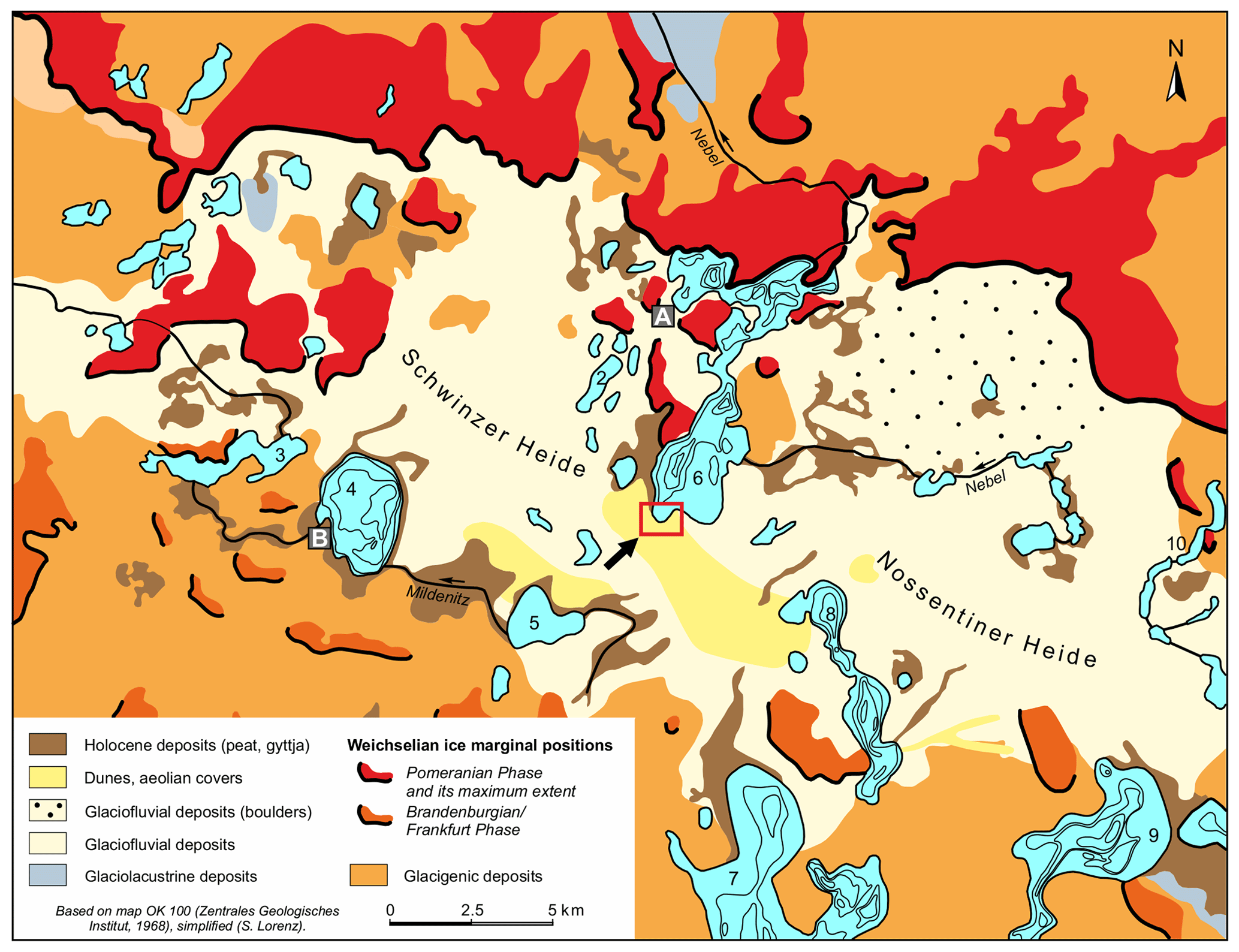
Figure 1Simplified map of Quaternary sediments and landforms in central Mecklenburg after ZGI (1968a) and ZGI (1968b). Important lakes are numbered: 1 Woseriner See, 2 Langsee, 3 Dobbertiner See, 4 Goldberger See, 5 Damerower See, 6 Krakower See, 7 Plauer See, 8 Drewitzer See, 9 Fleesensee, 10 Tiefer See (Klocksiner Seenkette). Krakow am See (A) and Goldberg (B) are small towns in the mapped area.
Krakower See has been the subject of several geoscientific investigations since the end of the 19th century (Geinitz, 1886; Möckel, 1892; Ahrens, 1913; Schulz, 1963; Richter, 1963; Lorenz, 2007). It is situated within the terminal moraines of the Pomeranian Phase and finds its southern lake shore in the outwash plain (Fig. 1). Because of its position within the Pomeranian moraine belt and an adjacent glacial outwash plain to the south (Nossentiner Heide), the lake basin displays a complex morphology as a result of the combined influences of meltwater erosion and, to a lesser degree, of glacial exaration. In the past, geomorphological, palaeohydrological and palaeoecological research has focussed on the investigation of lake terraces, lake sediments and the genesis of the Nebel, which cuts across the moraines, draining Krakower See via the Warnow into the Baltic Sea (Rother, 2003; Viehberg, 2004; Hübener and Dörfler, 2004; Lorenz, 2003, 2007; Kaiser et al., 2007). Krakower See (16.48 km2 with 21 islands, 47.5 m a.s.l., mesotrophic) is divided into five sub-basins orientated in a NNE–SSW direction. The proximity of the lake basin to the ice marginal zones and its morphometry suggest that the basin formation was predominantly forced by glacifluvial erosion (Schulz, 1963, 1994). An artificial dam, built in 1882, separates the lake at its narrowest part in the northern Untersee and southern Obersee. The river Nebel flows through the lake, entering Krakower See in the south-east and leaving it in the north-east using the aforementioned transverse valley across the Pomeranian moraine belt.
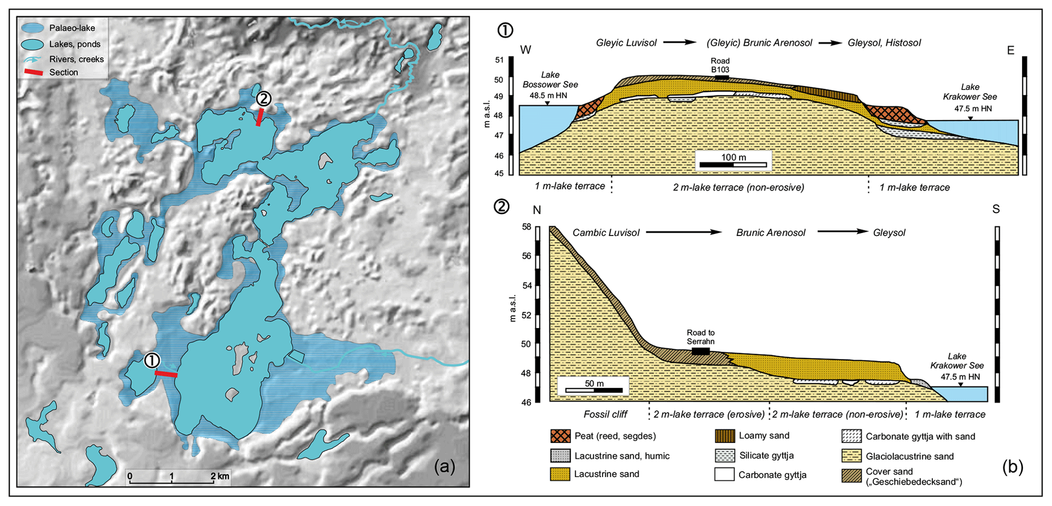
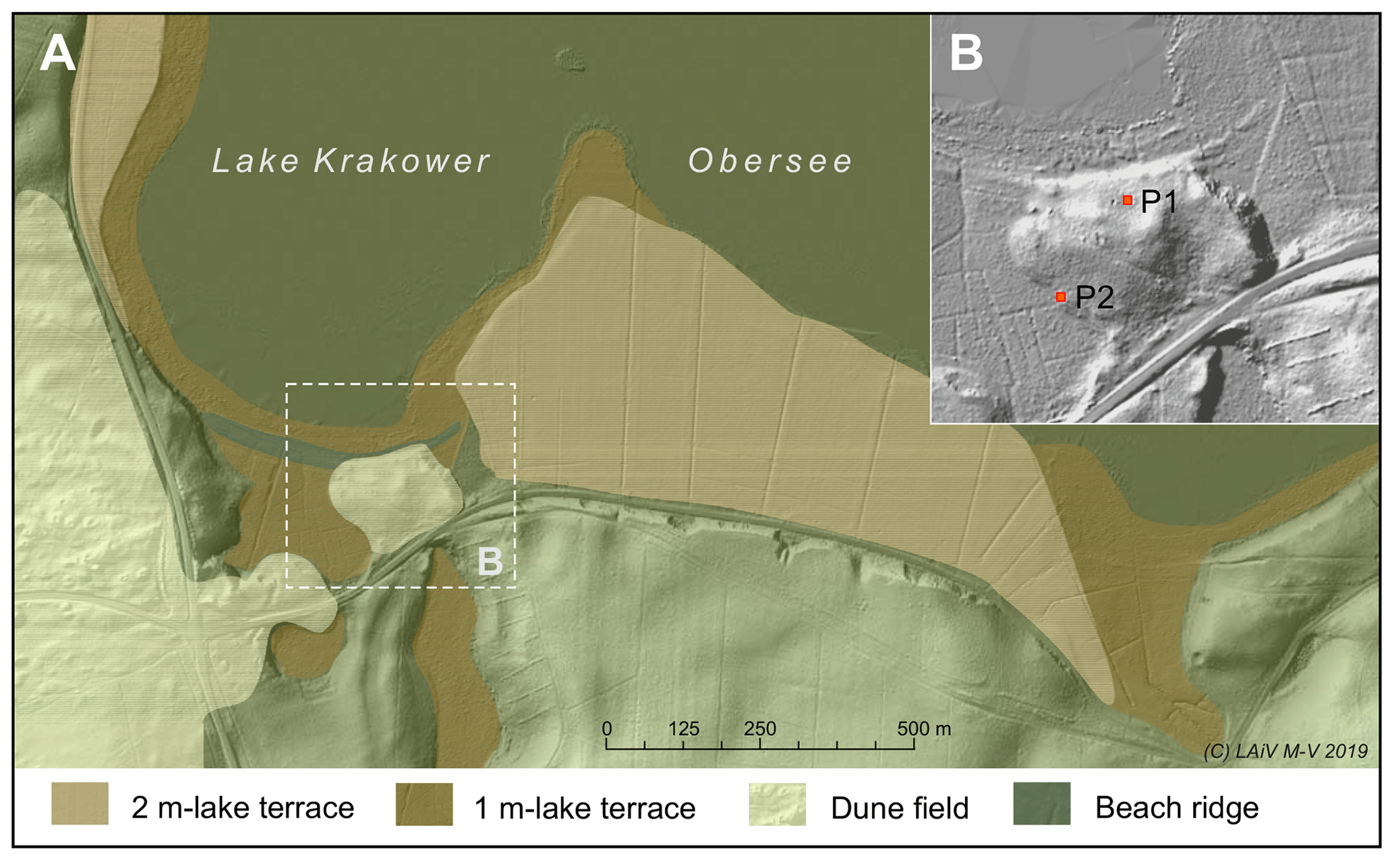
Figure 3Lidar DEM showing littoral landforms and dune fields south of Krakower Obersee (A). The inserted box (B) indicates the location of the presented soil profiles P1 and P2.
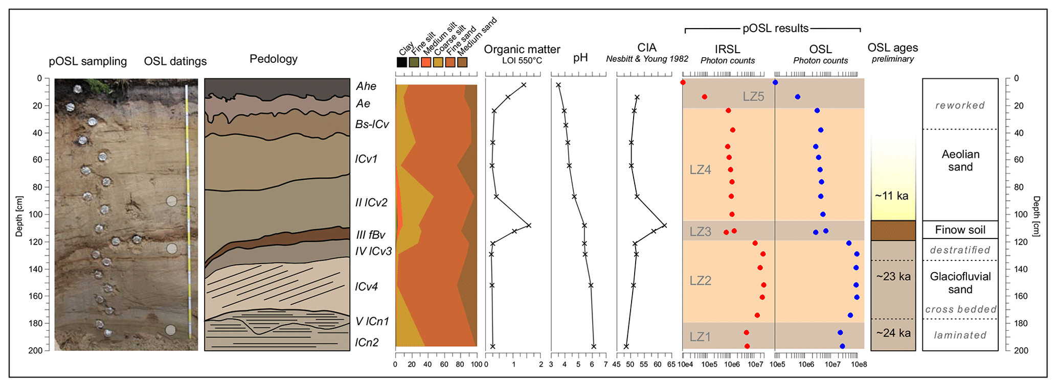
Figure 4Lithology, stratigraphy and pedology after Eckelmann et al. (2006); luminescence zones (LZ) and geochronology of the Late Glacial to Holocene dune profile P1.
The 2 m lake terrace represents the highest reconstructed lake level of Lake Krakow at 51 m a.s.l., about 3 m above the present level. The terrace distribution varies between 1.5 and 3.2 m above the present water level and can be traced at a width of 200–500 m around the entire lake, with the best development observed on the southern lake shore (Fig. 3). The 2 m terrace shows an inclination of 0.6 % towards the lake and is built up by sandy substrates, and locally by gravel. Calcareous, mollusc-free glacilacustrine sediments occur at a depth between 60 and 180 cm frequently showing periglacial deformations (Fig. 3). Based on the distribution of the 2 m terrace and its associated stratigraphies and morphologies, such as fossil cliffs and glacilacustrine sediments, a late-glacial palaeo-lake of about 30 km2 in size with a lake level at 51 m a.s.l. was reconstructed (Fig. 2). This palaeo-lake included 12 smaller and presently independent lakes in the vicinity, while the palaeo-lake itself had no drainage to the north. All islands of Krakower See show abrasion at the level of the 2 m terrace. So far, the age of the palaeo-lake has not been determined by absolute age dating. But the generally lower elevations, as well as the distinct differing content of microfossils (pollen, diatoms, ostracods, botanical remains) of lake sediments from the Allerød and the Younger Dryas in the littoral of the present lake, indicate an older Late Glacial palaeo-lake phase with more or less absent or not preserved microfossils displayed in lacustrine sediments incorporated in the 2 m terrace (Lorenz, 2007, pre-Allerød). The palaeo-lake phase ends during the final Younger Dryas with the incision of the transverse valley of the river Nebel causing a drop in the lake level (Rother, 2003; Kaiser et al., 2007). Lake terraces of Weichselian Late Glacial age are common features of Mecklenburgian lakes (Schulz, 1968; Kaiser et al., 2012).
The afforested dunes at southern Krakower See (Fig. 3, 53∘35′32′′ N, 12∘15′59′′ E) are of irregular shape and cover glacifluvial sands and gravels of the Pomeranian Phase. Their poorly developed or eroded top soils (predominantly podzolic Arenosols) include considerable amounts of incorporated charcoal, which points to a land-use history with deforestation resulting in a strong impact on the upper soil horizons (e.g. charcoal kilns). In addition to soils of late Holocene origin, a buried late glacial surface indicated by a Bwb horizon (brunic Arenosol) was revealed by pedological mapping (Lorenz, 2007; Kaiser et al., 2007). Based on its stratigraphic and pedological features, the brunic Arenosol has been classified as so-called Finow soil following Schlaak (1998, in German Finowboden). The Finow soil has been found and described by several authors in the northern parts of Germany and Poland and dates into the Allerød to Preboreal (e.g. Bussemer et al., 1998; Bogen et al., 2003; Kaiser et al., 2009; Küster and Preusser, 2010). Very close to a fossil cliff at the southern shore of Krakower See, a 10–20 cm thick Bwb horizon is preserved at depths between 60 and 120 cm. It represents a buried terrestrial surface without groundwater influence declining to the south. Thus, the buried surface at this location reveals a gradient orientated opposite to the present surface. A radiocarbon-dated charcoal particle from the Bwb horizon in profile P1 (Fig. 3) suggests the Late Glacial age of the palaeosol (12.9 ka calBP Kaiser et al., 2007), but further investigations with a portable optically stimulated luminescence (OSL) reader (pOSL Sanderson and Murphy, 2010) and common OSL datings have recently been carried out to gain an additional chronology for the formation of the overlying dunes (Fig. 4 Kaphengst, 2015).
The pOSL reader used for this study operates in continuous-wave stimulation mode with 880 nm for infrared stimulated luminescence (IRSL) and 470 nm for optical stimulated luminescence (OSL), where integrated IRSL and OSL signal intensities, depletion rates, and the IRSL ∕ OSL ratio are measured. IRSL and OSL signal intensities respond to a combination of the post-depositional age of the sediment, the luminescence sensitivity of the tested mineral grains, the local dose rates, the completeness of bleaching and potentially inherited luminescence signals due to prior cycles of environmental irradiation (Sanderson and Murphy, 2010). A total of 20 samples have been measured without any chemical pretreatment. Based on the luminescence data (photon counts from the portable reader) profile P1 has five luminescence zones (LZs, Fig. 4). LZ1 relates to the lowermost part of the profile with laminated glacifluvial sediments. LZ2 comprises six samples, where the first and the last one indicate a mixed signal. The samples in between show similar photon counts, pointing to a rapid sedimentation of LZ1 and LZ2. Lamination and the cross-bedding in both luminescence zones give evidence for glacifluvial environments associated with the Pomeranian Phase. LZ3 represents the Bwb horizon of the brunic Arenosol from which two measurements were obtained. For this horizon clay, silt, organic content (LOI) and the chemical index of alteration (CIA Nesbitt and Young, 1982) have the highest values. The CIA is used as a geochemical indicator for the weathering of feldspar and the associated formation of clay minerals, which helps to detect palaeosol formation, e.g. in homogeneous sediment successions (p. 10 Sheldon and Tabor, 2009). LZ4 comprising predominantly unstratified fine sand with low organic content continues with nearly the same photon counts as in LZ3 and shows decreasing pH and CIA values. LZ4 is of aeolian origin. LZ5 represents the present A horizon in fine sand with a distinct podzolic influence and linearly decreasing photon counts from 25 cm upwards, which indicates a stratigraphic break probably related to hiatus. This section is characterised by a minimum pH value of 3.6. However, the pOSL results illustrate nonuniform phases of sedimentation with the leaping photon counts.
The Bwb horizon of the brunic Arenosol lies in between laminated and cross-bedded glacifluvial deposits in the lower part and unstratified aeolian sediments in the upper part of profile P1. With similar stratigraphic position and lithology Küster and Preusser (2010) characterised the Bwb horizon for another site in southern Mecklenburg as a cover sand (GDS, Geschiebedecksand). The luminescence profiles show that the GDS has nearly the same photon counts as the overlying material. This indicates mixing of the material from the GDS and the aeolian coversands. The Finow soil shares properties with the cover sands (Geschiebedecksand), including poor sorting and a high content of finely grained aeolian sediment (Schlaak, 1998). Its depositional environment is assumed to have been influenced by weathering, but not by permafrost (p. 53 Bussemer et al., 1998). The preliminary OSL dates from profile P1 (Fig. 4) point to a Weichselian spectrum with Last Glacial Maximum ages for the well-stratified glacifluvial sediments and a Late Glacial age for the aeolian sands on top of the Finow soil. All three dates support the models of Finow soil formation mentioned above during the period from the Allerød to Preboreal.
The western fringe of the dune field comprises late Holocene dunes, which developed into the aggradational fringe of Krakower Obersee (Fig. 3, P2). Profile P2 shows a gleyic dystric Histosol covered by ca. 100 cm of aeolian sands. A remarkable feature in the profile is that organic soil horizons start 1 m above the present lake level. The dark and strongly organic fossil soil represents the lake level before the artificial lowering in 1836 by 1.05 m, which led to the formation of the 1 m lake terrace (Fig. 3 Lorenz, 2003). It is concluded that the dune field was built up by late glacial aeolian dynamics, as well as by the impact of historical land use. Both profiles indicate a constant reworking of the topsoils and late glacial aeolian sands.
Laboratory data are available from the authors.
SL, HR, MK and SK participated in the fieldwork. SK performed the laboratory analyses and luminescence measurements. MK and HR conducted the luminescence datings. SL wrote the paper and prepared all figures. HR, MK and SK contributed to the paper.
The authors declare that they have no conflict of interest.
We would like to thank the anonymous reviewer for helpful comments on the paper. We acknowledge support for the article processing charge from the DFG (no. 393148499) and the Open Access Publication Fund of the University of Greifswald.
This research has been supported by the DFG (German Research Foundation, grant no. 393148499) and the Open Access Publication Fund of the University of Greifswald.
Ahrens, H.: Terrassen an den Seen Mecklenburgs, Archiv des Vereins der Freunde der Naturgeschichte in Mecklenburg, 67, 1–55, 1913. a
Bogen, C., Hilgers, A., Kaiser, K., Kühn, P., and Lidke, G.: Archäologie, Pedologie und Geochronologie spätpaläolithischer Fundplätze in der Ueckermünder Heide (Mecklenburg–Vorpommern), Archäologisches Korrespondenzblatt, 33, 1–20, 2003. a
Bussemer, S., Gärtner, P., and Schlaak, N.: Stratigraphie, Stoffbestand und Reliefwirksamkeit der Flugsande im brandenburgischen Jungmoränenland, Petermann Geogr. Mitt., 142, 115–125, 1998. a, b
Cepek, A.: Zum Stand der Stratigraphie der Weichsel-Kaltzeit in der DDR, Wissenschaftliche Zeitschrift der Ernst-Moritz-Arndt-Universität Greifswald, Mathematisch-Naturwissenschaftliche Reihe, 21, 11–21, 1972. a
Eckelmann, W., Sponagel, H., Grottenthaler, W., Hartmann, K.-J., Hartwich, R., Janetzko, P., Joisten, H., Kühn, D., Sabel, K.-J., and Traidl, R.: Bodenkundliche Kartieranleitung. KA5, Schweizerbart Science Publishers, Stuttgart, Germany, 2006. a
Geinitz, F. E.: Die Seen, Moore und Flußläufe Mecklenburgs – Ein Versuch zur Erklärung der Entstehung der Seen und Wasserläufe der norddeutschen Diluviallandschaft, sowie der Küstenbildung, Commissionsverlag Güstrow, 1886. a
Hübener, T. and Dörfler, W.: Reconstruction of the trophic development of Lake Krakower Obersee (Mecklenburg, Germany) by means of sediment-diatom- and pollen-analysis, Studia Quaternaria, 21, 101–108, 2004. a
Kaiser, K., Rother, H., Lorenz, S., Gärtner, P., and Papenroth, R.: Geomorphic evolution of small river-lake-systems in northeast Germany during the Late Quaternary, Earth Surf. Proc. Land., 32, 1516–1532, 2007. a, b, c, d
Kaiser, K., Lorenz, S., Germer, S., Juschus, O., Küster, M., Libra, J., Bens, O., and Hüttl, R. F.: Late Quaternary evolution of rivers, lakes and peatlands in northeast Germany reflecting past climatic and human impact – an overview, E&G Quaternary Sci. J., 61, 103–132, https://doi.org/10.3285/eg.61.2.01, 2012. a
Kaiser, K., Hilgers, A., Schlaak, N., Jankowski, M., Kuehn, P., Bussemer, S., and Przegietka, K.: Palaeopedological marker horizons in northern central Europe: characteristics of Lateglacial Usselo and Finow soils, Boreas, 38, 591–609, https://doi.org/10.1111/j.1502-3885.2008.00076.x, 2009. a
Kaphengst, S.: Late Glacial and Holocene sedimentation and pedogenesis in the Pomeranian ice marginal zone (Mecklenburg): new insights from portable luminescence measurements and grain surface characterization, mathesis, University of Greifswald, Institute for Geography and Geology, 2015. a
Küster, M. and Preusser, F.: Late Glacial and Holocene aeolian sands and soil formation from the Pomeranian outwash plain (Mecklenburg, NE-Germany), E&G Quaternary Sci. J., 58, 156–163, https://doi.org/10.3285/eg.58.2.04, 2010. a, b
Lorenz, S.: Geomorphogenese, Sedimente und Böden der Terrassen am Krakower See in Mecklenburg – Untersuchungen zur jungquartären Paläohydrologie, Greifswalder Geographische Arbeiten, 29, 69–104, 2003. a, b, c
Lorenz, S.: Die spätpleistozäne und holozäne Gewässernetzentwicklung im Bereich der Pommerschen Haupteisrandlage Mecklenburgs, Phd thesis, Universität Greifswald, Greifswald, available at: https://nbn-resolving.org/urn:nbn:de:gbv:9-000425-2 (last access: 8 July 2019), 2007. a, b, c, d
Möckel, E.: Die Entstehung des Plauer Sees, des Drewitzer oder Alt-Schweriner Sees und des Krakower Sees, Druck der Rathsbuchdruckerei Güstrow, 1892. a
Nesbitt, H. and Young, G.: Early Proterozoic climates and plate motions inferred from major element chemistry of lutites, Nature, 299, 715–717, https://doi.org/10.1038/299715a0, 1982. a
Richter, G.: Untersuchungen zum spätglazialen Gletscherrückgang im mittleren Mecklenburg, Forschungen zur deutschen Landeskunde, 138, p. 98, Deutsche Akademie für Landeskunde, Bonn-Bad Godesberg, 1963. a
Rother, H.: Die jungquartäre Landschaftsgenese des Nebeltales im Bereich der Pommerschen Hauptendmoräne bei Kuchelmiß (Mecklenburg), Greifswalder Geographische Arbeiten, 29, 105–141, 2003. a, b
Rühberg, N., Schulz, W., von Bülow, W., Müller, U., Krienke, H.-D., Bremer, F., and Dann, T.: Mecklenburg–Vorpommern, in: Das Quartär Deutschlands, edited by Benda, L., Borntraeger, Berlin, 95–115, 1995. a
Sanderson, D. and Murphy, S.: Using simple portable OSL measurements and laboratory characterisation to help understand complex and heterogeneous sediment sequences for luminescence dating, Quat. Geochronol., 5, 299–305, https://doi.org/10.1016/j.quageo.2009.02.001, 2010. a, b
Schlaak, N.: Der Finowboden – Zeugnis einer begrabenen weichselspätglazialen Oberfläche in den Dünengebieten Nordostbrandenburgs, Münchener Geographische Abhandlungen, A49, 143–148, 1998. a, b
Schulz, W.: Eisrandlagen und Seeterrassen in der Umgebung von Krakow am See in Mecklenburg, Geologie – Zeitschrift für das Gesamtgebiet der Geologie und Mineralogie sowie der angewandten Geophysik, 12, 1152–1168, 1963. a, b, c, d
Schulz, W.: Spätglaziale und holozäne Spiegelschwankungen an den westlichen Oberen Seen Mecklenburgs, Archiv des Vereins der Freunde der Naturgeschichte in Mecklenburg, 12, 7–43, 1968. a
Schulz, W.: Die geologische Situation im Naturpark Nossentiner-Schwinzer Heide, Naturschutzarbeit in Mecklenburg–Vorpommern, 37, 33–40, 1994. a
Sheldon, N. D. and Tabor, N. J.: Quantitative paleoenvironmental and paleoclimatic reconstruction using paleosols, Earth-Sci. Rev., 95, 1–52, https://doi.org/10.1016/j.earscirev.2009.03.004, 2009. a
Viehberg, F. A.: Paleolimnological study based on ostracods (Crustacea) in Late-glacial and Holocene deposits of Lake Krakower See (Mecklenburg-Vorpommern, NE-Germany), Studia Quaternaria, 21, 109–115, 2004. a
ZGI: Zentrales Geologisches Institut – Geologische Karte der Deutschen Demokratischen Republik im Maßstab 1:100 000, Einheitsblatt 35 (Schwerin), 1968a. a
ZGI: Zentrales Geologisches Institut – Geologische Karte der Deutschen Demokratischen Republik im Maßstab 1:100 000, Einheitsblatt 36 (Neubrandenburg), 1968b. a